If you’re a fan of the legal ID’s routinely posted on this website, you may have noticed that I’ve been featuring some recordings from Colorado, Utah, New Mexico, and Arizona. Last summer, after a pandemic and staffing challenges repeatedly forced me to delay a roadtrip, I was finally able to hit the road for the long-awaited adventure! Here’s a recounting of the beginning of my journey:
Day 1: Black Canyon of the Gunnison and Mesa Verde

After two long days of driving from Wisconsin, and two nights in hotels feeding my media hobby, I arrived at Black Canyon of the Gunnison National Park prepared to find crowds of other people who, like me, were rushing to get outdoors on their first opportunity.
So, I wasn’t surprised when the Black Canyon visitor center’s parking lot was full. But it turned out to be the only full parking lot I would encounter on the entire trip!
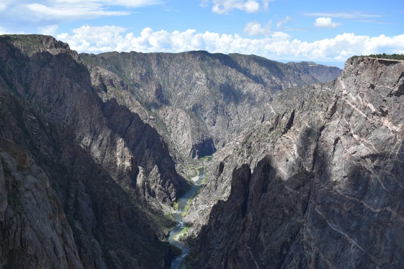
Viewpoints along the South Rim Road offer stunning views into the Black Canyon of the Gunnison River. The rock faces were already cast in shadows when I arrived at midday because the steep walls keep the sun out. The short trail at Cedar Point offers a look at interesting tree and plant life on the way to a huge overlook, while the popular short hike to Warner Point gave me a first feel for hiking at a much higher elevation than I’m used to (I got through it by taking plenty of breaks for snapshots!)
In the afternoon, a gorgeous drive through the San Juan National Forest took me to Mesa Verde National Park, where I would spend two nights to get a break after all of the driving.

Day 2: Mesa Verde
Mesa Verde offers many of the traditional hiking and overlook options that you find in all parks, but I kept my focus on the park’s main feature: ruins of Ancestral Puebloan homes from several eras.
The remains of pit houses are interesting to see but also so numerous that they begin to feel overwhelming if you stop at all of them. But coming around the bend of the Mesa Top Loop, overlooks finally offered the first views of the park’s best-known feature: cliff houses. In another part of the park, I was able to get a closer look at a cliff house on the self-guiding Step House tour.
Even though Mesa Verde is in Colorado, I felt like I was in New Mexico or Arizona, not just because of the change of scenery, but because the topography favored reception of stations to the south. I enjoyed driving while listening to stations such as the legendary KTNN:
Day 3: Four Corners, Bears Ears, Natural Bridges, Glen Canyon
I headed out of Mesa Verde towards Four Corners Monument, which brought me to three new states all at once: New Mexico (state number 25), Arizona (number 26), and Utah (number 27). The site is operated by the Navajo Nation and the four sides of the monument are lined with booths for Navajo artisans to sell their work.

The next stop was harder to find because it’s less developed and less well-marked. The Valley of the Gods lies within the area that was re-designated as part of Bears Ears National Monument shortly after my visit. A small brown sign points to the Valley of the Gods Road from U.S. Highway 163. Turning off the highway, I couldn’t tell which dirt road I was supposed to take. I went left at first, but the road seemed to die out. Then I doubled back and saw a car coming out on the other road. Yep, I should’ve gone the other way!
The bumpy gravel and dirt road takes drivers past numerous scenic peaks and has the feel of a Western off-road adventure but with the safety of a road that’s rated for passenger vehicles. There were a few people with trailers who appeared to be taking the opportunity to get a free campsite along the road (albeit with no services). It was 100 degrees but the view was great from the AC-cooled vehicle!
The 17-mile road through Valley of the Gods takes about an hour to drive and eventually connects with Highway 261, which quickly brought me to another adventure: the Moki Dugway. The gravel switchback route was built by a mining company, and it certainly felt like I was driving through a mine closer to home on Minnesota’s Iron Range.

At the top of the Dugway is a straight paved highway that took me towards my next destination, Natural Bridges National Monument, with the Bears Ears that give the region its name looming in the distance. Natural Bridges has a beautiful scenic drive but it was mostly empty during my visit, possibly due to the heat or possibly due to a nearby highway closure. After stopping at a few breathtaking overlooks, the short hike to Owachomo Bridge offered an interlude of quiet Western solitude. I had it all to myself until I headed back up the hill, where I encountered a guy with a British accent who said this is one of his favorite spots. I agree.
Since the highway I’d planned to take was closed, I headed back down towards the Dugway and found another great adventure: a gravel road to an overlook that I had skipped on my way north. It turned out the road leads to the Muley Point Overlook in Glen Canyon National Recreation Area, and I was glad I didn’t skip it the second time. The overlook offers stunning views into the canyon and I had it all to myself. It was a third piece of Western solitude in one day and turned out to be one of the best points of the entire trip, completely unplanned!
Next week: Visiting Canyonlands, Arches, and a delicate situation at Delicate Arch
LINK: More Off Topic columns


1 thought on “Off Topic: Roadtripping to the Four Corners Region”
Comments are closed.