When you see a national map during a weather forecast, you expect it to list the big cities.

New York. Miami. Los Angeles. Toronto.
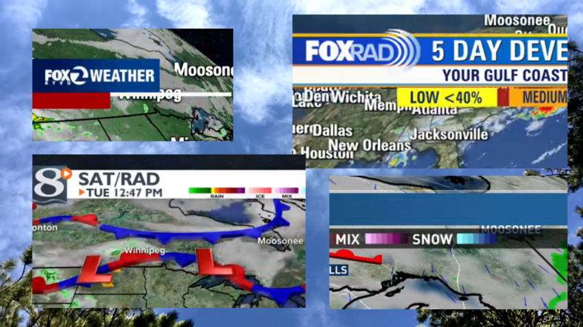
Moosonee, Ontario.
Oh, haven’t you noticed? Moosonee has found its way onto the corners of weather maps across America!
After noticing the isolated northern Ontario community appear on weather maps during newscasts from several cities, I decided to check a few dozen stations across the continental U.S. It turns out Moosonee is sometimes shown on local weather maps in at least four time zones on stations owned by numerous companies and affiliated with all networks.
You can click on each image to get a closer look at how Moosonee showed up on each map.
In all cases, Moosonee is listed alongside much larger cities (well, technically, Moosonee is incorporated as a town). Many times, it’s the only Ontario community listed, with larger places like Toronto and Thunder Bay not shown.

So, how did a community of about 1,500 people show up on weather maps across America?
With dozens of U.S. stations carried on Canadian cable and satellite providers, some might initially assume that stations are trying to serve Canadian viewers. But the community appears on plenty of U.S. stations that are not seen anywhere north of the border.

(For the record, listings on TVTV.ca show that residents of Moosonee may see stations from Detroit, Rochester, NY, Boston, Buffalo, and/or Seattle depending on which provider they use. Like most of rural Canada, the community no longer has any over-the-air TV reception.)
The real reason for Moosonee showing up on so many newscasts may come from the way that local TV stations create their weather forecasts. Most have contracts with organizations such as The Weather Company for software and equipment that create graphics for live on-air use.

Melissa Medori, who works in external communications for The Weather Company and IBM Watson Advertising, could not confirm which stations are their clients, but explained that “location/city labels are plotted automatically based on the zoom level and what other cities/towns are within a buffer, and they are then displayed based on size.”
So, in other words, Moosonee may be showing up because the software is trying to fill a spot on the map.
It’s also an issue that can come up when a station zooms into a particular part of its viewing area, prompting viewers to ask why their town doesn’t show up but another town does.
Medori said stations have the ability to change the settings manually, and the ability to set up manual labels for cities and towns.

The choice of which cities appear on the Canadian side of the weather map is likely not a big priority for U.S. TV stations unless they are near the border. Perhaps not many have noticed that this small town is showing up on their maps so regularly.
So, what does Moosonee think about all this?
I reached out to the Town of Moosonee government to see if they were aware that their community is shown so often on U.S. weather maps. Jay Monture, the town’s economic development officer, responded with a note saying that he finds it fascinating and that his sister had noticed Moosonee on stations from California and Buffalo.

“On the behalf of the Town of Moosonee I send our greetings to all your readers and if readers see Moosonee on the TV weather map, please like Jon’s blog indicating you saw us on TV,” Monture wrote.
Moosonee itself was founded in 1903, but Indigenous people have lived in the area for thousands of years. Fur trading had already been happening in the region for several centuries prior to Moosonee’s founding. Northern College has a brief history of the region.
On the weather maps, it may appear that Moosonee is on James Bay, but it’s actually 12 miles south of the bay on the Moose River.

Moosonee is home to Ontario’s only saltwater port. Don’t bother planning a roadtrip because there is no road to Moosonee — access is by rail or plane.
The town’s website welcomes tourism by saying the lack of road access makes them unique and promotes itself as a spot to “touch the edge of the Arctic.” Activities include whale and seal watching in the spring and fall as well as camping, hunting, fishing, and the chance to see the Northern Lights.
Monture provided some pictures of the weather station in Moosonee:


The next time you watch a weather forecast, keep your eye out for Moosonee!